Horseback Riding and the Carson Valley a tradition for over 150 years.
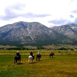
Horseback Riding and Equestrian events in the Carson Valley
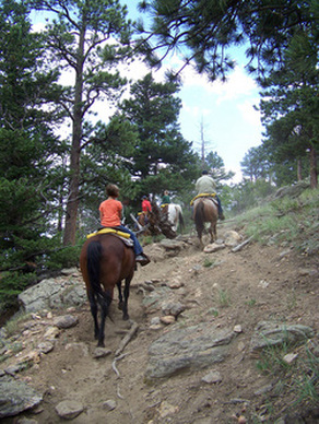
Traveling the Carson Valley on horseback is a tradition that stretches back over 150 years. You can transport yourself back to the days of “Bonanza” and picture yourself riding alongside Ben, Adam, Hoss, and Little Joe Cartwright on the valley’s many equestrian trails. Carson Valley horseback riding ranges from short organized trail rides to horse camping on rides that last a week or more. To the west, you can ride portions of the Tahoe Rim Trail, the Pacific Crest Trail, or the Tahoe to Yosemite Trail. To the east, the Pine Nut mountains beckon, with opportunities to ride along sand washes, explore old mining trails and jeep trails, or head out cross-country. Sheep Camp and any number of small valleys provide water and grazing, and camping is free on BLM land. However, it is advisable to carry a GPS for cross-country riding, and take care not to trespass on posted private land parcels. You can find stables in Carson Valley, Carson City, and Zephyr Cove that conduct trail rides and riding lessons.
Annual Trail rides can be found at events such as the Genoa Cowboy Festival in early spring and the Annual Carson Valley days in June. The Rodeo Grounds at the Douglas County Fairgrounds holds Roping, Barrel racing and Rodeo events all summer long.
Large real estate lots for raising horses are easy to locate and many people whom always wanted to raise a horse or two and learn to ride have found their dream location here in the Carson Valley
Trails in and around the Carson Valley
Bently-Kirman Trail
Bently-Kirman Trail(map)
Minden NV 89423
athomas@tnc.org
http://www.carsonvalleytrails.org/Trails-KirmanTrail.html
Explore 3.8 miles of hiking trail at Kirman Field in the Carson Valley. The Nature Conservancy has partnered with the Carson Valley Trails Association, local Eagle Scouts, area businesses and the property owner to construct the hiking trail system.At Kirman Field, the Carson River winds its way in braided channels, supporting willows and wetlands that sustain many animals and migratory birds. The trail provides visitors with access to these natural areas and to the amazing panoramic views that Kirman Field has to offer.
The Nature Conservancy has been working at Kirman Field since 2005, when a conservation easement was acquired with funding from Question 1 and the Nevada Department of Wildlife to preserve the incredible floodplain lands that surround the 4 miles of Carson River that flow through the property. In establishing the conservation easement at Kirman Field, the property owner, Mr. Donald Bently, and the Conservancy envisioned a place where conservation would benefit both nature and people; demonstrating that habitat protection, cattle ranching, and public access can coexist. The Kirman Trail fulfills that vision.
Because Kirman Field is both a natural area and a working cattle ranch, the trail is open to hikers only with no horses, bikes, or dogs allowed.
Click here to view and print the Bently-Kirman Trail Map
Big Meadow Trailhead - East Trail
Big Meadow Trailhead - East Trail(map)
Lake Tahoe NV 89448
http://www.tahoerimtrail.org/
This part of the trail is open to hikers, mountain bikers and equestrians. Follow the paved road for 100 yards before going right onto the trail. The next 2 miles you will climb gently with switchbacks through a mostly thick forest of predominantly Jeffrey pine and red fir. Here you junction with the Grass Lake Trail so be sure to watch for Tahoe Rim Trail signs. From here as you continue your journey you will pass through several small meadows with many wildflowers and two rock outcroppings that make great viewing spots. From these you can see the northwest area of Lake Tahoe and mountains to the east and south. After a total of 4.4 miles you will reach Saxon Creek Trail (aka "Mr. Toad's Wild Ride). For an added challenge you can go on an extra mile (2 round trip) to Freel Meadows for more open views and wildflower viewing; otherwise find a nice spot for lunch and some relaxation before returning to your car.
Classification: Medium
Distance: 8.8 miles round trip
Low/High Elevations: 7300' to 8030'
Highlights: Views of the entire southern Sierras and great wild flower displays. Also the privilege to hike on the first Tahoe Rim Trail section ever completed
Location: The Big Meadow trailhead is on the north side of Highway 89 approximately five miles south of US 50Big Meadow Trailhead to Big Meadow Trail
Big Meadow Trailhead to Big Meadow Trail(map)
Lake Tahoe NV 89448
http://www.tahoerimtrail.org/
A trail leads 200 yards from the end of the lot to Hwy 89-cross with caution and look for a trail marker on the south side of the highway. You will begin by following the trail to the south on rocky terrain. As you climb the moderately steep trail you will be enjoying a thicker forest of Jeffrey pine, western white pine and fir. After 0.2 miles you will pass to the left of Big Meadow Creek, a large bed filled with huge granite boulders and lined with aspen trees. Another 0.1 miles and the trail becomes more moderate. As you walk close to a stream on level ground, your legs get a rest. When you reach the junction be sure to continue straight ahead on the TRT. Soon you will reach Big Meadow, which with great views of the surrounding mountains it is a wonderful place for lunch. However be sure to bring back anything you bring out with you.
Classification: Easy
Distance: 1.4 miles round trip
Low/High Elevations: 7300' to 7520'
Highlights: Large open meadow with potential to see some of the most stunning wildflower displays the Tahoe Rim Trail has to offer.
Location: The Big Meadow trailhead is on the north side of Highway 89 approximately five miles south of US 50.
Users: This part of the trail is open to hikers, mountain bikers and equestrians. Mountain bikers should note that the Tahoe Rim Trail joins the Pacific Crest Trail in 4.9 miles and bikes are not allowed on the Pacific Crest Trail.Fay-Luther Trail
Gardnerville NV 89423
http://www.carsonvalleytrails.org/Trails-FayLuther.html
The 2.4-acre Faye-Luther Trailhead is a popular gateway to the rugged Carson Range. Located off Foothill Road south of State Route 207, Kingsbury Grade. The trail is intended not only for hikers and horse owners, but also for a broad range of non-motorized uses. This includes backcountry skiers, snowshoers and mountain hikers and bikers, dogs okay. The hike is considered moderately strenuous after the first mile, but offers breathtaking views of Carson Valley. Doggie bags receptacle is available at entrance to trail. Future plans to connect with Job’s Peak Ranch Trail.
Distance: 4 miles
Classification: Family friendly, light to moderate
Low/High Elevation: 1600’ to 4800’
Directions: Driving south on US 395 into Minden, NV, take Highway 88 for 6.5 miles to Fairview/Foothill, drive 1.75 miles to trailhead on the left. Driving north on US 395 toward Gardnerville, NV, turn left on Dresslerville (Route 756), follow to Centerville Rd, continue to Highway 88 and follow directions going south.
Click here to view and print the Fay-Luther Trail Map
Genoa Peak Trail
Genoa Peak Road(map)
Lake Tahoe NV 89460
Ride along a ridgeline with scenic views of the Lake Tahoe Basin to the west and Carson Valley to the east. Several spurs off the main road access peaks, Genoa Peak being the highest (1,150'). An excellent 10-mile loop off the main ridge is an option.
Trailhead: Genoa Peak Road
Elevation Gain: 2,000'
Difficulty: Intermediate
Getting There: From the Carson Valley take State Route 207 (Kingsbury Grade) and turn right on North Benjamin Road which turns into Andria Drive. Continue to the end of the pavement and park.Grover Hot Springs State Park
P.O. Box 188(map)
Markleeville CA 96120
Phone: 530-694-2248 or 530-694-2249
grover@gbis.com
http://www.parks.ca.gov/
Only 35 minutes from Gardnerville, the 700-acre park lies in Hot Springs Valley at an elevation of nearly 6,000 feet, with mountains rising abruptly on three sides. Hawkins Peak, at 10,023 feet, is three miles northwest of the valley, and Markleeville Peak, 9,417 feet, lies four miles to the southwest.
• One-mile self-guided loop trail, with descriptions of the area's natural history begins at the Campground Bridge.
• Charity Valley Trail - an additional hike is from the extra vehicle parking area where you can access the Charity Valley Trail. There are three options: either to the water falls (1.5 miles), to Burnside Lake (5 miles) or Charity Valley (6 miles). Trail markers identify the three trails available.
One of the park's two concrete pools is fed by the runoff from six mineral springs with an average temperature between 102 and 104 degrees F. The park has 76 sites equipped with fire pits and grills, cupboards, bear-proof lockers and tables. Two of the 76 sites are designed specifically for wheelchair use. Campsites may be reserved by calling 1-800-444-7275. Driving Directions: Take State Route 88 South to Woodfords. Turn left onto State Route 89 to Markleeville. In the middle of Markleeville, take the paved road west for about four miles to the park. Parking fee.Job’s Peak Ranch Trail
Job’s Peak Ranch Trail(map)
Gardnerville NV 89410
http://www.carsonvalleytrails.org/Trails-JobsPeakRanch.html
The trail begins at the trailhead located on Foothill Road and follows an easement through a private development. The first portion is through a sage-covered open-space area. After a gradual uphill, the trail enters a forested area, crosses a small creek, and continues to climb through the forest until it currently ends at the CA/NV state line. It will eventually proceed into California where it will reach the USFS boundary and at its highest point and best view of the Carson Valley. Once on USFS lands it is possible to cross country to Job’s Canyon. The trail is intended for hiking (pedestrian use only), dogs okay on leash. Future plans to connect with Fay-Luther Ranch Trail.
Distance: 1.5 miles
Classification: Family friendly, light to moderate
Low/High Elevation: 4540’ to 4800’
Directions: Driving south on US 395 into Minden, NV, take Highway 88 to Mottsville, turn right and drive to Foothill Rd, turn left and drive 2.5 miles to trailhead. Driving north on US 395 toward Gardnerville, NV, turn left on Dresslerville (Route 756), follow to Centerville Rd, continue across Highway 88 to Foothill Rd, turn left and drive ~1 miles to trailhead.
Click here to view and print the Job's Peak Ranch Trail Map
Kingsbury Grade North Trail
Kingsbury Grade North Trail(map)
Lake Tahoe NV 89449
http://www.tahoerimtrail.org/
This trail rolls up and down along short stretches. You will wander through an open forest of Jeffrey pine and white fir while enjoying the smell of tobacco brush and the brilliant green of Manzanita. After 0.5 miles of hiking you will come to a marked vista spot. Follow this spur trail for some nice views of castle rock and the west shore of Lake Tahoe.
Classification: Easy
Distance: 1 mile round trip
Low/High Elevations: 7780' to 7860'
Highlights: Views of castle rock, Emerald Bay & Mt. Tallac
Location: The Kingsbury Grade North trailhead at the end of Andria Drive. To get there take Highway 207, Kingsbury Grade, toward the pass (i.e., north from Carson Valley). 0.3 miles north of Daggett pass turn (right from Carson Valley) onto North Benjamin Drive. This road becomes Andria Drive. Go 1.9 miles to the end of the road.
Users : This trail is open to hikers, mountain bikers and equestrians.Pine Nut Trails Mountain Biking
Gardnerville NV 89410
Trailhead is located in the open parking lot area by the big tree off of Pine Nut RoadSierra Foothills Road Bike Tour
Carson City NV 89701
http://www.bicyclenevada.com/
Bikers along this ambling route in the shadow of the Sierra Nevada encounter deer, golfers, hot springs, antique stores, gingerbread homes and rustic ranches stretching across the scenic Carson Valley. The route, despite the rural setting, offers several scenic spots to stop, shop, eat or rest. Begin in Genoa or Minden. You can begin your journey at the base of Kingsbury Grade and proceed north on Foothill Road. Be sure to be aware of the automobile traffic along this road.
Spooner Summit
Snow Valley Peak Trail(map)
Lake Tahoe NV 89450
http://www.tahoerimtrail.org/
Beginning at the Spooner Summit north trailhead you will follow the Tahoe Rim Trail uphill. Though the trail starts off steeply it soon becomes gentler, as you pass through a Jeffrey Pine forest. After 2.25 miles you will see a vista sign, follow this 100 yard spur trail for rewarding views. Continuing through the mostly shady forest you will find occasional filtered views during the next 1.4 miles. At that point you will pass the trail for North Canyon campground (one of two required campsites on this section of trail). As you continue on another 1.05 miles you may notice the change from white fir to red fir and the change of scenery to Eagle Valley with its sprawling Carson City. Your final climb is one mile on an exposed west facing ridge with sagebrush, tobacco brush, plenty of granite boulders and a few stunted whitebark pines. During this final mile you will finally be able to enjoy full open views of Lake Tahoe. Best of all, you are rewarded with views of Marlette Lake. Seeing these two lakes side by side is truly spectacular. This is a great spot to have lunch before turning around for your next 6.2 miles back.
Classification: Hard
Distance: 12.4 miles round trip
Low/High Elevations: 7150' to 9214'
Highlights: Marlette Lake, gentle shaded uphill and full views of all sides of Lake Tahoe. Location: The Spooner Summit North trailhead is on the north side of highway 50, ½ mile east of the junction with Highway 28.
Users: This part of the trail is open to hikers and equestrians. Due to State Park regulations this section of trail is closed to mountain bikers. It is recommended that mountain bikers interested in this area try riding the flume trail.Tahoe Rim Trail
Tahoe Rim Trail(map)
Lake Tahoe NV 89450
Phone: 775-298-0012
http://www.tahoerimtrail.org/
The 165-mile Tahoe Rim Trail forms a loop around Lake Tahoe - riders should expect lofty views of granite peaks, vibrant green meadows and the bright blue water of the lake. The trail, which was completed in fall 2001, offers a variety of terrain and challenges for mountain bikers. Some sections of the trail are closed to mountain bikers or allow biking only on even-numbered days.
Elevation Gain: 4,000'
Difficulty: Intermediate to advanced
Getting There: The Tahoe Rim Trail circles the lake and bikers will find nine trail-heads. The bike trail heads south from Spooner Summit; the next trailhead is where State Route 207 (Kingsbury Grade) meets U.S. 50, just north of Stateline.
